CLIMATE ISSUE: Coastal erosion; Coastal erosion; Flooding; Increase storm frequency and intensity; Sea-level rise; Storm surge | SECTOR: Coastal and environmental management; Disaster recovery; Landscape Architecture; Tourism and recreation development; Trail planning | STAGE: Climate disaster (Hurricane Fiona) occurred in September 2022; Plan completed, September 2023; First phase of construction completed, Summer 2025 | TYPE OF ACTION: Post-disaster recovery; Reduced vulnerability to future climate events | TYPE OF SETTING: Rural coastal community
Project Overview
The Grand Bay West Trail Renewal Plan is a comprehensive disaster recovery and climate resilience framework completed by Mills & Wright Landscape Architecture for the restoration of the Grand Bay West Trail network following the destruction of Hurricane Fiona in 2022 in Channel-Port aux Basques, Newfoundland and Labrador. The renewal plan realigns the trail to reduce vulnerability to future climate impacts and improve long-term coastal resilience, enhancing community accessibility, and reintroducing recreational amenities and infrastructure, while also incorporating new interpretive elements to tell the story of Fiona's impact.
Location: Channel-Port aux Basques, Newfoundland and Labrador
Actors: Mills & Wright Landscape Architecture; Town of Channel-Port aux Basques (client)
Funding Agency(s) / Programs: Atlantic Canada Opportunities Agency; Hurricane Fiona Recovery Fund
Issue: Disturbed sensitive coastal ecology; Destroyed and vulnerable coastal infrastructure
Action: Restoration of the Grand Bay West Trail network to reestablish recreation and public access, enhance resilience, and protect and strengthen coastal ecology, following the destruction of Hurricane Fiona
Results: Enhanced environmental protection; Improved accessibility; Infrastructure recovery and redevelopment; Positive social and human health and wellbeing impacts; Reduced vulnerability to climate impacts
Case Study Lead: Mills & Wright Landscape Architecture
Project Background
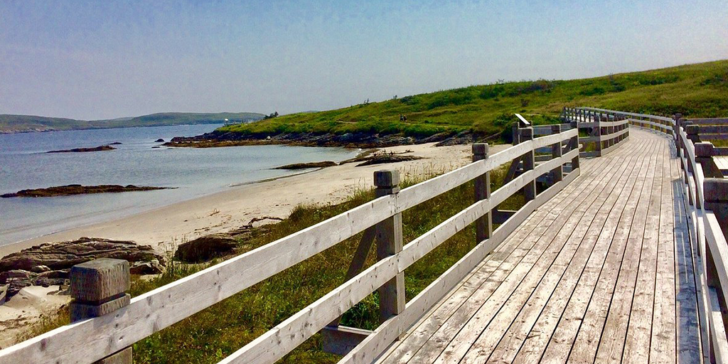
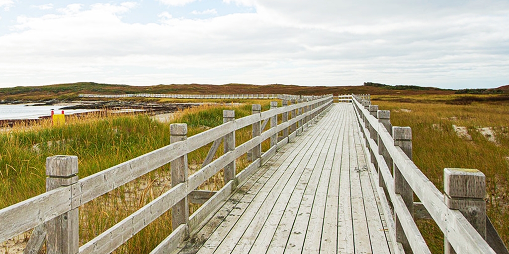
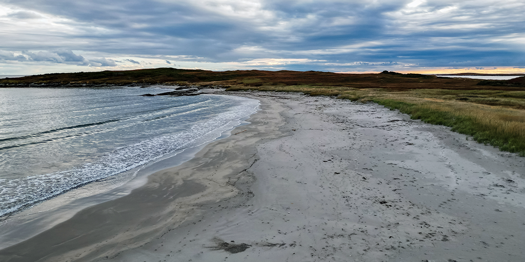
The Grand Bay West area of Channel-Port aux Basques is a culturally significant coastal landscape defined by sandy beaches, rocky coastlines, wetlands, and views of the Cabot Strait and Table Mountains. This area is also home to the Grand Bay West Trail, a highly valued public amenity for recreation, reflection, and coastal connection. While initially established to support local tourism, the trail has become a beloved space and plays an important role in the health and well-being of the community. As such, the Town has made significant long-term investments over time to improve the experiential and ecological quality of the trail network.
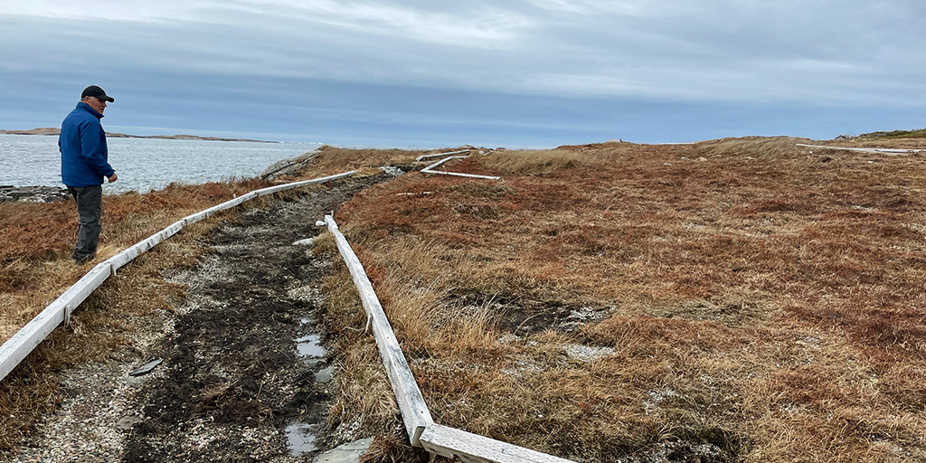
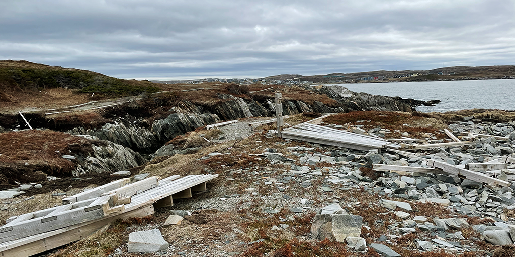
On September 24 2022, Hurricane Fiona brought water levels of 2.73 metres to the area (the highest levels on record) and the storm surges had severe consequences, including the loss of life and destruction of homes. It dramatically altered the landscape by disrupting coastal ecology, leveling sensitive sand dunes, and eroding sections of the coastline. Fiona caused extensive damage to large portions of the trail and its surrounding infrastructure. This loss was felt deeply within the community, significantly impacting physical and mental health, and the social and place-based connections that were intrinsically tied to the landscape.
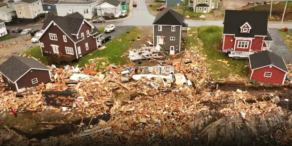
Rather than pursuing rapid reconstruction, the Town recognized that rebuilding the trail without serious reconsideration and external input would likely result in the same vulnerabilities under increasingly severe coastal conditions from climate change. In response, the Town issued a public request for proposals to reroute the damaged trail, positioning the project as an opportunity to contribute meaningfully to the community and advance climate adaptation strategies to enhance the trail system and establish long-term resilience. Following the storm, Mills & Wright Landscape Architecture (hereafter Mills & Wright) was engaged to develop the renewal plan that would establish an adaptive long-term vision and guide the restoration of the trail. The official Grand Bay West Trail Renewal Plan was delivered to the Town of Channel-Port aux Basques in September 2023.
Understanding and Assessing Impacts
To inform trail planning and design, Mills & Wright conducted a series of comprehensive assessments that included: community mapping to document key cultural features and community population profiles; a review of relevant municipal planning policies and long-term frameworks; a review of climate data to understand regional climate projections, sea-level rise, and coastal hazards; an extensive trail analysis to determine trail alignments, infrastructure vulnerabilities and accessibility; field work to observe site conditions; and documenting best practices and emerging adaptation design strategies in trail and recreation planning.
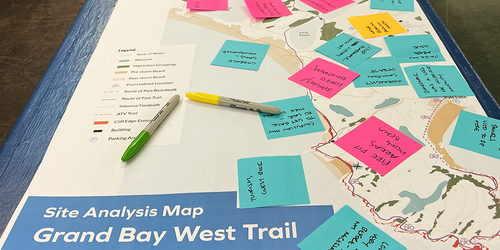
Community engagement was critical to the assessment process, and included a community open house held in May 2023 and an online survey to gather feedback from residents and trail users. Gaining community support for rerouting the trail to a more protected location was a key objective, requiring meaningful dialogue and engagement to build a greater understanding of the potential long-term climate risks to the community. The engagement process revealed other key priorities that informed design decisions, such as trail realignment and construction, wayfinding elements, accessibility, environmental considerations, drainage and surface conditions, as well as the need for supporting amenity features including benches, picnic tables, and washrooms.
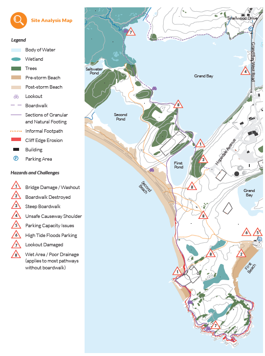
The trail inventory assessment also provided critical information for understanding the trail's condition and was used to identify culturally-defining features, opportunities and challenges, and elements requiring protection, enhancement, or both. Town staff and council members accompanied the Mills & Wright design team during portions of the inventory process, contributing insights on pre-Fiona conditions. This inventory process helped the design team document flora and fauna, topography and surface materials, significant natural and built features, viewpoints, ecological connectivity, and public access.
In addition to the inventory assessment, ecological assessments also provided an understanding of ecological conditions and helped to identify habitat and sensitive or significant areas. Prior to Hurricane Fiona, the beaches at Grand Bay West featured some of the most intact and ecologically significant sand dunes and intertidal zones on the island of Newfoundland. Importantly, these sand dunes provide natural coastal protection and serve as nesting grounds for the piping plover, an endangered bird species. While the sand dunes and wetlands were expected to gradually recover naturally, the redeveloped infrastructure was sited away from these areas to prevent disrupting natural ecosystem regeneration, and additional habitat protection measures were included in the Renewal Plan to support ecological processes without interference.
Use of Climate Information in Decision-Making
Newfoundland and Labrador is already experiencing the effects of climate change, with rising average temperatures, increased frequency of extreme weather events, and escalating impacts from coastal erosion, sea-level rise, and storm surges – impacts that are often disproportionately experienced in smaller rural communities, where limited resources and capacity heighten vulnerabilities. In western and southern Newfoundland, sea levels are projected to rise by 80–90 centimetres over the next century, amplifying risks to the community and the coastal and marine ecology.
Integrating climate data into the trail renewal project enabled the design team at Mills & Wright to evaluate potential risks, and prioritize resilient solutions and ideas to ensure that the strategies outlined in the Renewal Plan address both current vulnerabilities and long-term projected climate impacts. To do so, the design team reviewed a range of resources on climate change including The Way Forward: On Climate Change in Newfoundland and Labrador, as well as the Coastal Change in Newfoundland and Labrador: A Handbook for Policy Makers and the Public (2020). These documents provided critical insight into the anticipated changes in the region and informed design strategies for the trail network, revealing four key areas of coastal impact: more frequent and severe storms, storm surges, flooding, and erosion.
Aerial imagery from a geospatial data visualization tool, EagleView Canada, provided the design team with critical insights on pre- and post-hurricane conditions by mapping storm surge extents, erosion areas, and inland impacts. The observed impacts from Hurricane Fiona and the storm surge levels were then overlaid with projected climate data to inform decision-making. This visualization method provided a compelling and accessible way to communicate climate data, with areas more likely to be affected by storm damage clearly identified and avoided in the new trail alignment.
Since the completion of the Grand Bay West Trail Renewal Plan, Newfoundland and Labrador has developed two complementary Climate Change Action Plans: the 2025-2030 Climate Change Mitigation Plan; and the 2025-2030 Climate Change Adaptation Plan. Together, these documents will guide efforts and assist communities, government, and organizations in advancing resilience and adaptation to minimize risk and manage impacts of anticipated climate changes.
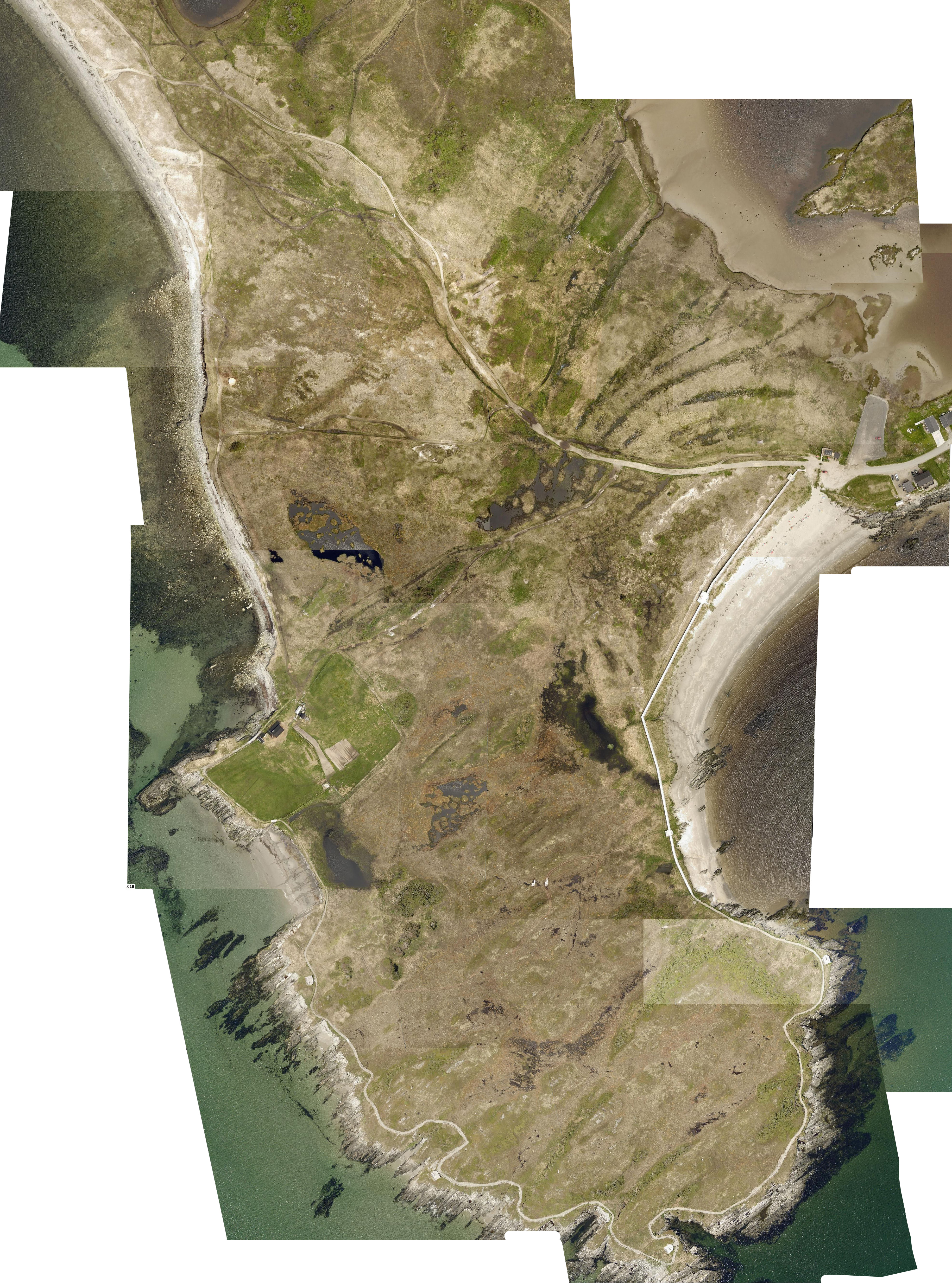
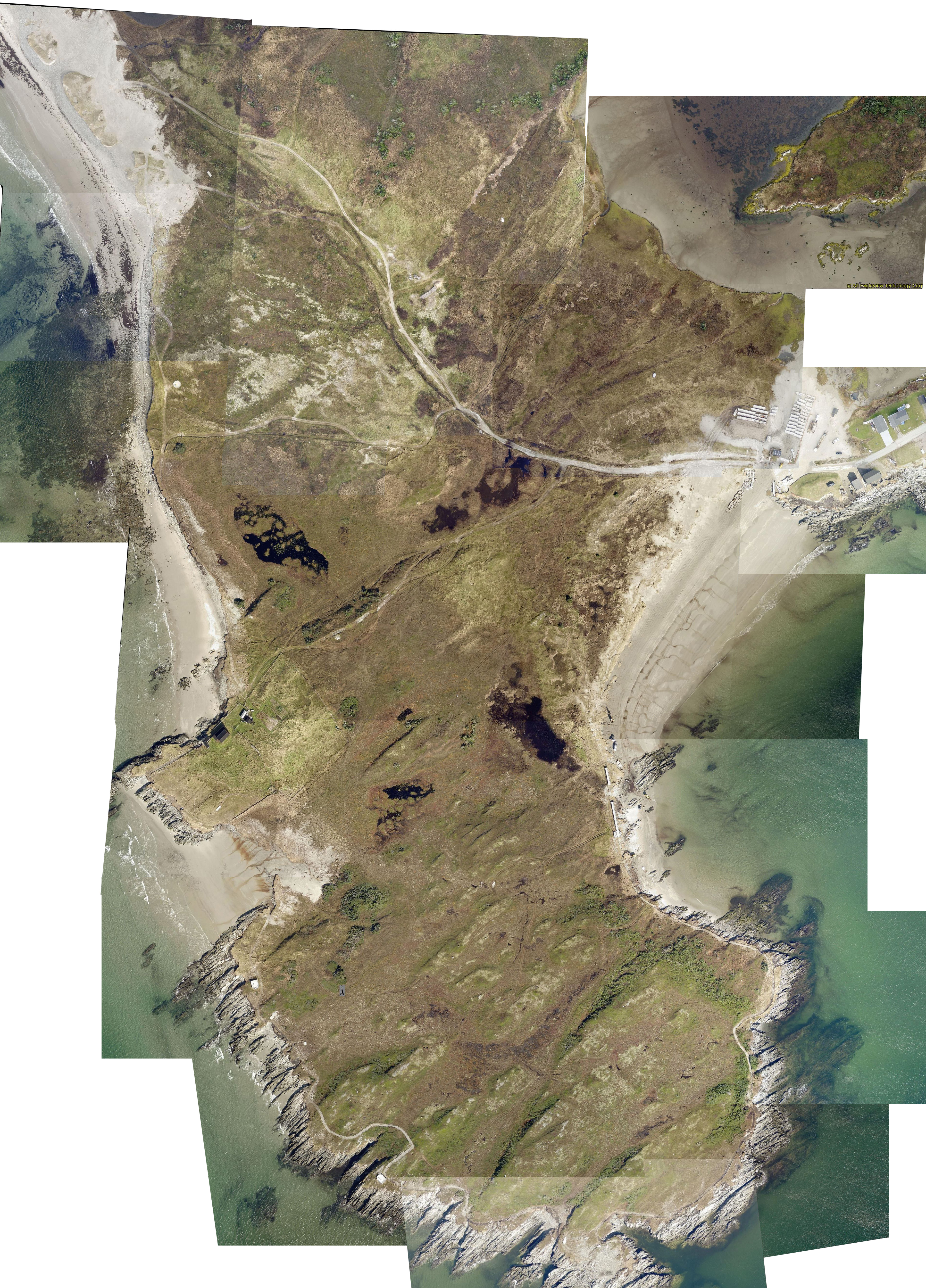
Geospatial comparison of 2019 (left) and 2022 (right) aerial imagery via EagleView Canada. (Image: M&W)
Identifying Actions
During the trail planning and design phase, Mills & Wright reviewed and compiled emerging adaptation strategies to inform the renewal framework. Among the key resources used, the CSLA’s Adaptation Primer Two: Preparing for Climate Change (2018) helped to guide the decision-making framework which considered interventions along three complementary pathways: defer, persist, or migrate.
To align recreational planning with anticipated environmental changes, the Climate Change Adaptation Strategies and Approaches for Outdoor Recreation (2019) provided targeted actions for implementing adaptation strategies specifically related to recreation infrastructure. In addition, the provincial General Tourism: Market Readiness Guidelines were referred to, ensuring the plan aligned with general recommendations for trail design, construction, and maintenance, while supporting tourism and enhancing visitor experience.
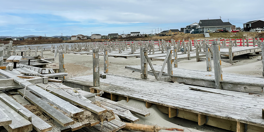
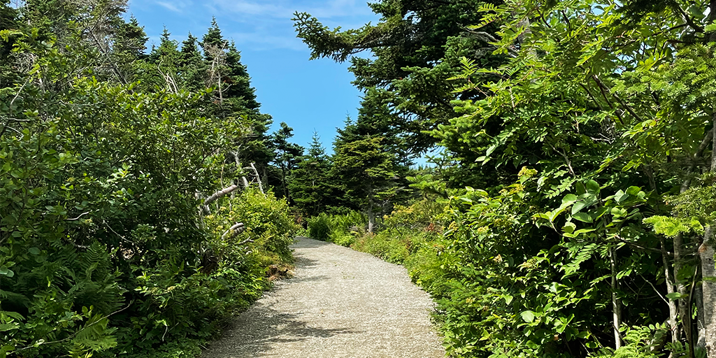
Site assessments and climate data revealed that the trail could not be reconstructed in its previous alignment as it would replicate vulnerabilities to future climate events. This realization presented the Town with an opportunity not only to redesign and reroute the trail network, but also to educate the community and the trail users on the impacts of climate change. Hurricane Fiona destroyed the boardwalk in the First Beach area of Grand Bay West, leaving the concrete footings and foundations exposed and damaged. The Town later stored these remnants on the beach after cleaning up the debris. These structures now serve as interpretive elements, providing a compelling visual reminder of the destruction caused by Hurricane Fiona and the community’s resilience in disaster recovery.
Summary of design intentions:
- Rebuild in a resilient and sustainable manner: develop a trail route that is forward-thinking, adaptable and capable of withstanding future climate change impacts
- Reestablish recreational opportunities that reconnect the community and visitors to the landscape: reinstate the trail and provide new opportunities for passive recreation that support mental and physical health and wellbeing
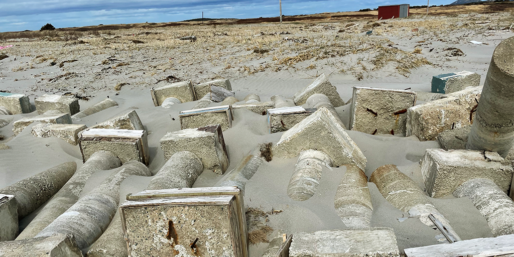
- Tell the story of Fiona: leverage interpretive elements to reflect what was lost, foster community connection, and build awareness of climate change impacts
- Protect the natural environment: protect, restore and enhance coastal ecology, critical habitats, and the natural landscape features
- Develop an inclusive trail: offer wayfinding and diverse trail options that are appealing and accessible to a variety of needs
Implementation
The Renewal Plan developed by Mills & Wright represents a preliminary step in recovery efforts; however, implementation of the Plan will require an organized effort, dedicated champions, strategic partnerships, and further investment. A $20,000 grant from the Fiona Recovery Fund was awarded to the Town of Channel‑Port aux Basques specifically to aid in rebuilding the trail, acknowledging its importance to the community and its value as a significant tourist feature. While funding sources include disaster recovery and tourism, financial priorities thus far have pertained primarily to housing reconstruction and relocation of vulnerable homes. As the Town moves toward implementation, securing long-term funding mechanisms will be critical to deliver the recommendations to the trail network. Accordingly, the Renewal Plan outlines available grants and funding programs to assist with the development of the trail.
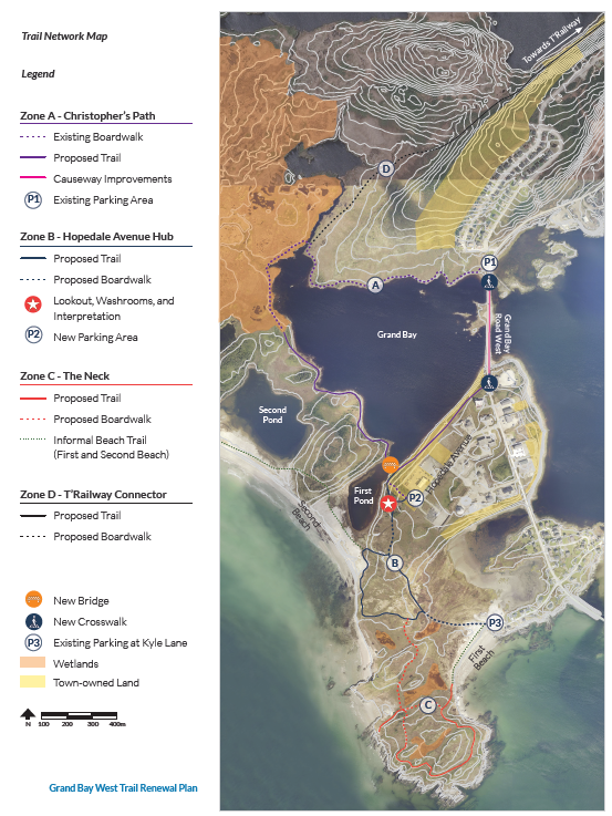
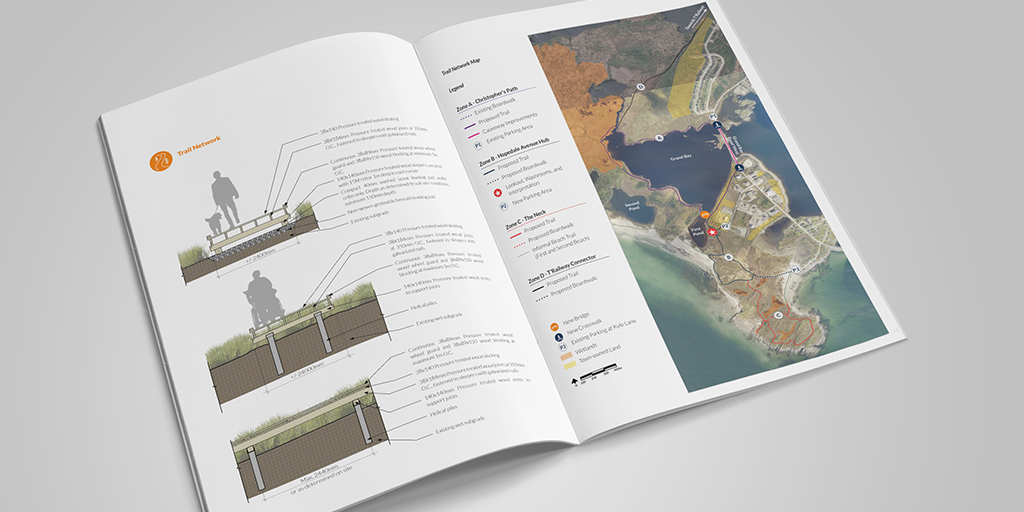
Implementation outlined in the Renewal Plan is structured in phases, organized by zones each with varying levels of intervention and anticipated climate impact. The recommendations are intended to guide the Town in gradually restoring the trail network, and include suggested actions pertaining to: trailhead development and parking; trail types and overall hierarchy (e.g., boardwalk, granular, causeway improvements, and beach paths); improvements in accessibility and inclusion (including the Rick Hansen Foundation guidelines); site furnishing; wayfinding and signage; interpretive features; and maintenance. The upgrades to the trail network are divided into four zones: Zone A – Christopher's Path; Zone B – Hopedale Avenue Hub; Zone C – the Neck; and Zone D – Trailway Connector.
In 2024, the Town engaged Mills & Wright to develop detailed construction drawings for the first phase of Zone A – Christopher's Path. The goal of this work was to develop a looped trail section that would connect and extend the existing trailhead. Construction started in early 2025 and was completed in late summer 2025, providing a new granular path and rest areas, with wayfinding signage and seating to be added as funding allows.
Outcomes and Monitoring
The community response to the Renewal Plan has been overwhelmingly positive, with residents expressing that their ideas and priorities were reflected in the recommendations. Importantly, the engagement and anticipated trail restoration have fostered a renewed sense of hope for the community after the devastation caused by Hurricane Fiona, reinforcing a sense of connection to the landscape and its redesign. Early responses to the new section of Christopher’s Path have been positive and have generated a growing enthusiasm for the anticipated future trail developments, underscoring the value of community-scale interventions in disaster recovery and climate adaptation.
The Grand Bay West Trail Renewal project demonstrates how meaningful outcomes for community development can be achieved without large budgets or high-profile designs. Strong municipal leadership and early project champions at the Town of Channel-Port aux Basques initiated the project with a clear goal of advancing forward-thinking, adaptive design. From the outset, the Town actively sought external guidance on best practices to restore the trail network and incorporate emerging climate adaptation strategies. This early commitment to establish greater climate resilience distinguishes the Grand Bay West Trail Renewal project from conventional frameworks that focus on protection, accommodation, or retreat.
The Grand Bay West Trail Renewal Plan exemplifies an advanced approach to post-disaster rebuilding, integrating climate data and adaptation practices to deliberately avoid replicating climate vulnerabilities, an approach distinct from conventional reconstruction projects in this community. Climate disasters often act as catalysts for investment and long-term resilience planning, especially in small Canadian communities where limited resources and capacity can constrain proactive adaptation efforts. While the impacts of Hurricane Fiona were severe, the post-disaster context revealed the true extent of the community's vulnerability to climate impacts and presented an opportunity to comprehensively rethink the standard design process and development of community infrastructure, which likely would not have existed otherwise. The previous trail system, though beloved by the community, was highly vulnerable to extreme weather events, and was largely disconnected and inaccessible in areas, with the boardwalk and part of Christopher’s Path serving as one of the few accessible features. The actions presented in the Renewal Plan will introduce a more resilient, integrated looped trail system that improves trail user experience and creates new opportunities for community gathering and recreation, fostering social connection, health and wellbeing. The renewed trail will also incorporate enhanced accessibility features, while serving as an educational tool and visual reminder of climate change impacts.
Highlights of the Landscape Architect
The landscape architects at Mills & Wright led the development of the Grand Bay West Renewal Plan, overseeing the site analyses and design process. The scope of this work included conducting comprehensive landscape evaluations to understand pre- and post-disaster conditions of the site, and to determine the projected future impacts based on climate data. This analysis in turn guided the application of best practices for climate-informed decision-making, ensuring that the future Grand Bay West Trail is resilient to climate conditions while also addressing wayfinding, placemaking, tourism and overall user experience through incorporating diverse trail options that accommodate varying accessibility needs.
A particularly meaningful contribution of the Mills & Wright team was the development of the interpretive element that reflects the cultural and emotional significance of the landscape. The remnants of the former boardwalk, intentionally integrated as interpretive features, offer moments for pause, reflection, and storytelling – illustrating the role of memorialization and place in landscape design. These contributions further emphasize the capacity of the landscape architecture profession in connecting people to landscape and shared experiences, particularly in post-disaster contexts. By combining technical expertise with cultural and ecological considerations, the team envisioned a resilient trail system with improved functionality that is deeply meaningful to the community.
Landscape architects adhere to a code of ethics and possess a professional, legal, and ethical duty to advance sustainable design and protect the health and safety of the public and the environment. Through ongoing professional training, they are uniquely equipped with the knowledge and capacity to directly shape climate-resilient communities. In post-disaster recovery landscapes such as Grand Bay West, this responsibility expands to encompass emotional resilience and healing, creating new opportunities for active recreation and social connection that support health and wellbeing and deepen relationships between people and the natural environment.
Next Steps
The Town of Channel-Port aux Basques intends to continue with trail construction to fully implement the Grand Bay West Renewal Plan as funding becomes available. At the time of writing , there are no immediate scheduled phases for construction.
Future phases of construction will provide opportunities to incorporate updated evaluations of evolving climate impacts, particularly increased rainfall and its effects on drainage and trail infrastructure. Recent challenges in Channel-Port aux Basques related to heavy rainfall and washouts further underscore the growing need for adaptive design approaches. Future stages of project delivery should incorporate updated climate projections and enhanced strategies for drainage and material selection.
The Grand Bay West Renewal Plan presents a model to other small rural communities facing similar challenges, illustrating how climate adaptation can and must be integrated into the design process without adding unnecessary complexity. While many standard design principles outlined in the Renewal Plan remain applicable, ongoing monitoring and refinement will be essential to ensure that the long-term performance of the trail system remains resilient and aligns with changing climate conditions.
Resources
- CSLA (2018) – Adaptation Primer Two
- Government of Newfoundland and Labrador – The Way Forward: On Climate Change in Newfoundland and Labrador
- Government of Newfoundland and Labrador (2020) – Coastal Change in Newfoundland and Labrador: A Handbook for Policy Makers and the Public
- Government of Newfoundland and Labrador – 2025-2030 Climate Change Mitigation Plan and 2025-2030 Climate Change Adaptation Plan
- Government of Newfoundland and Labrador – General Tourism: Market Readiness Guidelines
- Hurricane Fiona Recovery Fun
- Mills & Wright Landscape Architecture – Grand Bay West Trail Renewal Plan, Project Description
- O’Toole, D., Brandt, L. A., Janowiak, M. K., Schmitt, K. M., Shannon, P. D., Leopold, P. R., Handler, S. D., Ontl, T. A., & Swanston, C. W. (2019). Climate Change Adaptation Strategies and Approaches for Outdoor Recreation. Sustainability, 11(24), 7030.
![]()
This case study was prepared and authored by Sabrina Careri (Design Communications) on behalf of the CSLA.
It forms part of the landADAPT Case Study Series, an educational resource and advocacy tool developed by the CSLA with the support of Natural Resources Canada’s Climate Change Adaptation Program.