CLIMATE ISSUE: Urban heat island effect; Increased flood risk and stormwater runoff | SECTOR: Landscape Architecture; Master Planning; Urban Ecology; Blue-green Infrastructure | STAGE: Master plan adopted; Implementation in progress | TYPE OF ACTION: Master plan; Blue-Green infrastructure development; Revitalization | TYPE OF SETTING: Post-industrial; Urban
Project Overview
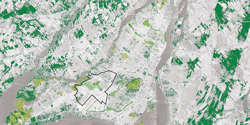
The Saint-Laurent Biodiversity Corridor plan is a 20+-year vision developed by LAND Italia (today LAND Canada, hereafter LAND), civiliti, Table Architecture and Biodiversité Conseil, that serves as an actionable strategy to transform the industrial area of the Saint-Laurent borough in Montreal, into a continuous urban ecological corridor. Guided by the Corridor de biodiversité de Saint-Laurent: Plan directeur d'aménagement master plan, the 450 hectare project aims to enhance biodiversity and improve Montreal's overall climate resilience using a unique framework of blue-green-social infrastructure, to establish a connected ecological network, manage stormwater, mitigate urban heat, and improve urban livability.
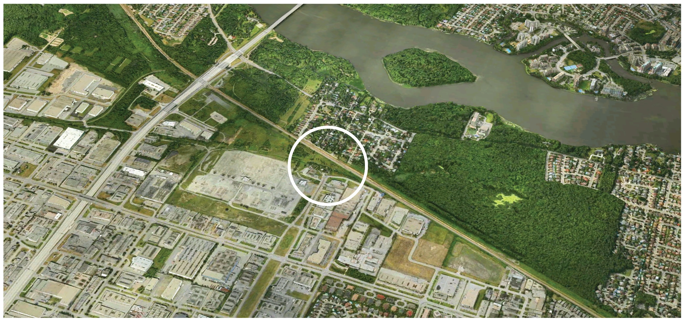
Location: Montréal, Québec
Actors: LAND Italia (Canada office) (landscape architects, designers); civiliti (landscape architects, project managers); Table Architecture (landscape architects); Biodiversité Conseil (ecologists); Arrondissement de Saint-Laurent (client); with le Ville de Montreal (client).
Funding Agency(s) / Programs: Multiple funding streams, including municipal budgets, participatory initiatives, federal climate adaptation programs, and anticipated partner contributions
Issue: Biodiversity loss; Urban habitat fragmentation; Loss of ecological connectivity; Habitat degradation
Action: Phased implementation of a continuous blue-green corridor that integrates social infrastructure, to restore ecological connectivity, enhance urban biodiversity, increase green space accessibility, and support climate resilience
Results: Biodiversity recovery; Creation of habitat; Ecological connectivity; Improved green space accessibility; Improved stormwater management
Case Study Lead: LAND Italia (Canada office)
Project Background
The Saint-Laurent corridor extends from Cavendish Boulevard and Highway 40 (a branch of the Trans-Canada Highway) to the Bois-de-Liesse and Bois-de-Saraguay parks, passing through ecologically significant woodlands including the Cavendish, Marcel-Laurin, and Cavendish–Raymond-Lasnier–Beaulac–Poirier areas. Historically the site of the former Cartierville Airport, this sector of the borough of Saint-Laurent has long served as a major industrial-commercial hub and as a result, has undergone extensive hardscaping since the 1960s. Over time, the predominantly asphalt surfaces combined with the sparse tree canopy and vegetation cover, created one of the largest urban heat island areas across the region, compromising livability for both people and urban ecology.
The identification of the corridor site first emerged during policy development and broader efforts to recover biodiversity, and re-naturalize and demineralize the heavily industrial landscape, grounded in a long-standing municipal priority to improve environmental sustainability. In 2004, la Ville de Montréal (the City of Montreal) adopted la politique de protection et de mise en valeur des milieux naturels (the Policy on the Protection and Enhancement of Natural Environments), designating ten ecoterritories across the city to protect and enhance biodiversity in areas of high ecological value. Among the ecoterritories was the Bertrand Creek watershed, through which the Saint-Laurent corridor site was recognized in 2015 for its potential to serve as a key ecological corridor for connectivity. The project was officially initiated two years later, when the City held a two-stage, landscape-led multidisciplinary national competition to re-naturalize the highly industrial and fragmented landscape and enhance biodiversity, and foster human and environmental health and wellbeing for Saint-Laurent.
The winning vision, developed by LAND, civiliti, Table Architecture and Biodiversité Conseil in 2018, formed the basis of the master planning document. Plan d’aménagement (2019) established an actionable long-term vision for restoring biodiversity and connectivity within the city’s ecological network, as well as short- and medium-term context-specific interventions for each sector of the borough. By supporting biodiversity recovery and ecological functioning, while simultaneously enhancing urban livability, the master plan establishes a unique, integrated framework of blue-green-social infrastructure that is centered around coexistence to support thriving human and ecological populations.
Understanding and Assessing Impacts
Prior to the competition, in 2016 the Borough undertook a series of environmental, social, and spatial site studies to identify opportunities to improve environmental quality and enhance human health and wellbeing by restoring ecological conditions on underutilized land. At the time, a central focus of the municipality was on improving connectivity between fragmented ecosystems using corridors and buffer zones. They completed various mapping exercises documenting forests, wetlands, rivers, and other ecosystems to understand their spatial relationships and to identify connectivity opportunities across scales of terrestrial, hydrological and aerial systems. The Borough also held a comprehensive engagement process to align biodiversity and social objectives, which helped to situate the corridor project within broader city-wide initiatives, and formed the basis of the programming requirements for the design competition.
Following the competition, the project partners conducted three primary site analyses:
- A systematic mapping of soil conditions and stormwater infrastructure across the site;
- A comprehensive assessment and inventory of the local fauna and connectivity, including the relation to human activity and accessibility; and
- The Biodiversity Report (Annex A1 to the Plan Directeur d’Aménagement), which synthesized data from previous surveys, official publications and fieldwork, and provided the scientific foundation for mapping and analysis.
Additional assessments of the paved surfaces, materiality, and canopy distribution were conducted, and revealed elevated heat island exposure, affecting both ecological quality and human thermal comfort. This information presented key vulnerabilities that would eventually guide design direction:
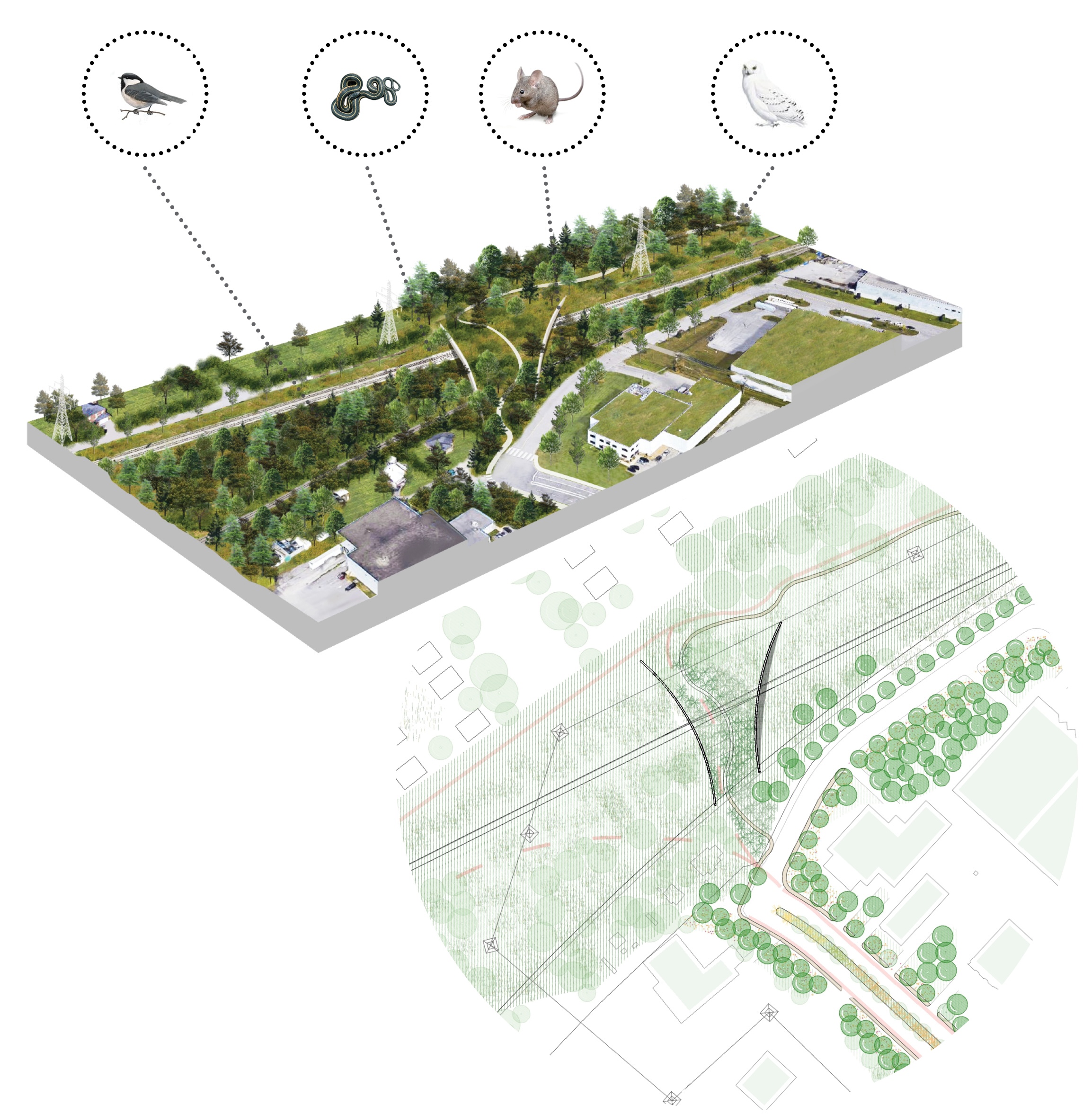
- Gaps in ecological connectivity, including fragmented and uneven vegetation distribution that restricts ground and aerial fauna movement, disconnected water bodies that limit aquatic and amphibian habitats, and intensive human activity and road infrastructure that pose significant barriers to terrestrial wildlife mobility.
- Flood-prone areas / areas of high flood risk, resulting from limited permeable surfaces and insufficient sustainable drainage systems (SuDS), such as stormwater retention areas, rain gardens, and infiltration zones.
- Urban heat island exposure, driven by extensive paved surfaces and a lack of tree canopy and vegetation cover.
Use of Climate Information in Decision-Making
The vision for the Saint-Laurent Biodiversity Corridor was developed using a multidisciplinary and multidimensional approach, considering both the neighbourhood and the regional scale, and focused on coexistence between human activity and ecological systems within the heavily developed context of Saint-Laurent. While no dedicated climate modelling was undertaken, principles of climate resilience and adaptability were embedded into the long-term framework, and design interventions were informed by city-wide objectives and projections, such as those within the Climate change adaptation plan for the Montréal Urban Agglomeration 2015-2020. The design approach also relied heavily on established best practices and professional benchmarks, such as standard shade coverage targets to determine whether environmental conditions were sufficient.
While climate adaptation was not the original focus, strategies that improve livability such as increasing canopy cover, enhancing green infrastructure, and mitigating urban heat islands, aligned ecological and community resilience goals. Managing climate and microclimate conditions was a central focus of the master plan, prioritizing an increase in tree canopy cover and establishing a secondary network of street-level vegetation to reinforce ecological networks, enhance livability, and reduce urban heat. Interventions also incorporate permeable paving and integrated stormwater management strategies along main streets and in areas identified as underperforming to contribute to greater climate resilience. Additional vegetated retention areas, rain gardens, and infiltration zones are proposed to mitigate stormwater and reduce flood risks, based on future projections that indicate an increase in frequency and intensity of storm events. Although the initial strategies were informed by qualitative and spatial analysis, the implementation framework is long-term and intentionally adaptable, enabling strategies to be refined and expanded as updated quantitative climate data evolves and becomes more accessible in practice.
Identifying Actions
In addition to the project partners, the vision for the Saint-Laurent Biodiversity Corridor was developed collaboratively with the Borough of Saint-Laurent staff and was conceived as a methodological framework for nature positivity (i.e., establishing productive forms of nature) to enable successive ecological processes. The process brought together a multidisciplinary team including landscape architects, urban designers, ecologists, and cultural and social planning professionals. Additional ongoing consultation also occurred with a steering committee (Comité de suivi) composed of design experts (many of whom were also members of the competition jury). This collaborative design-governance structure enabled continuous iterative exchanges across project actors.
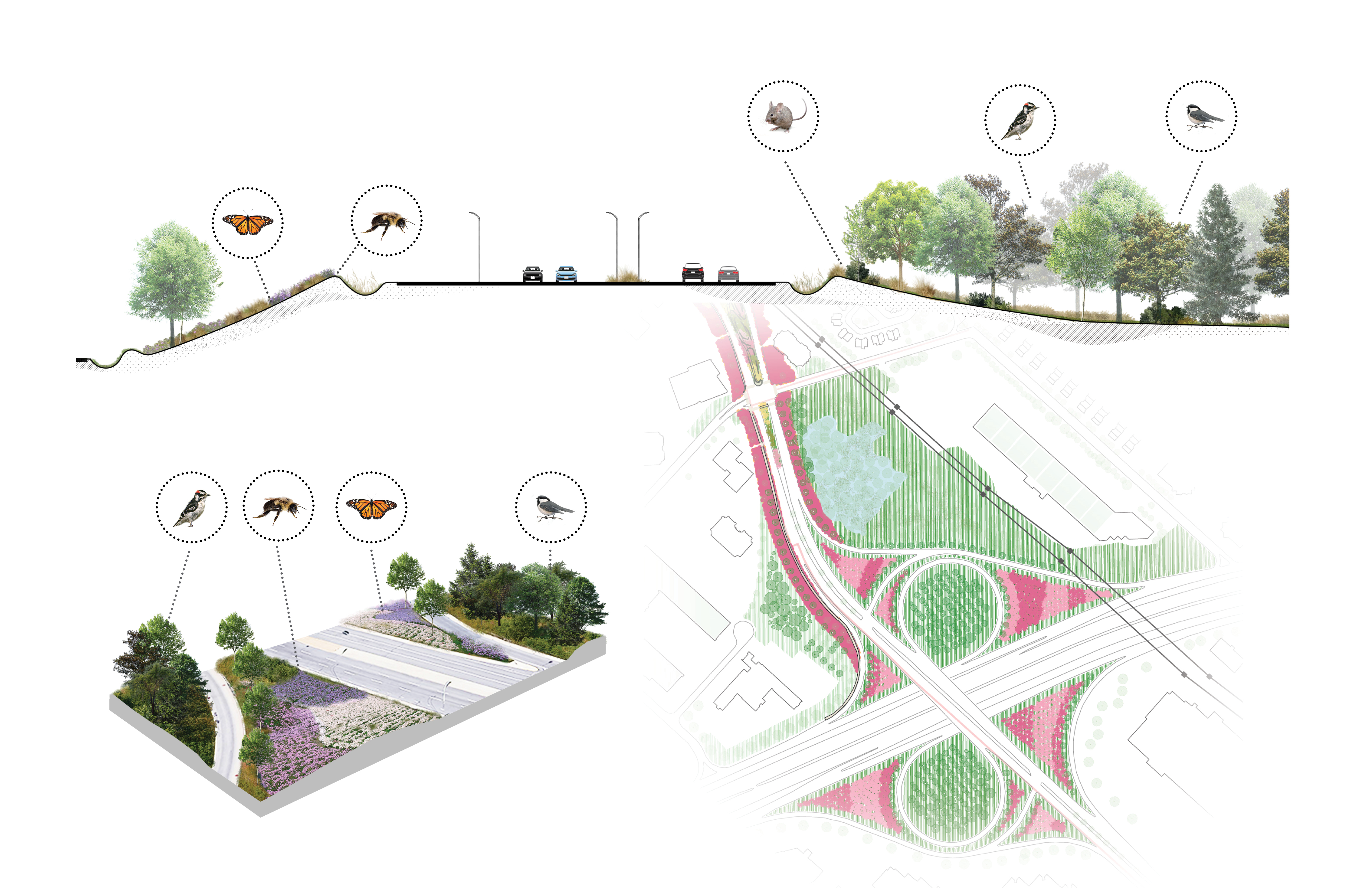
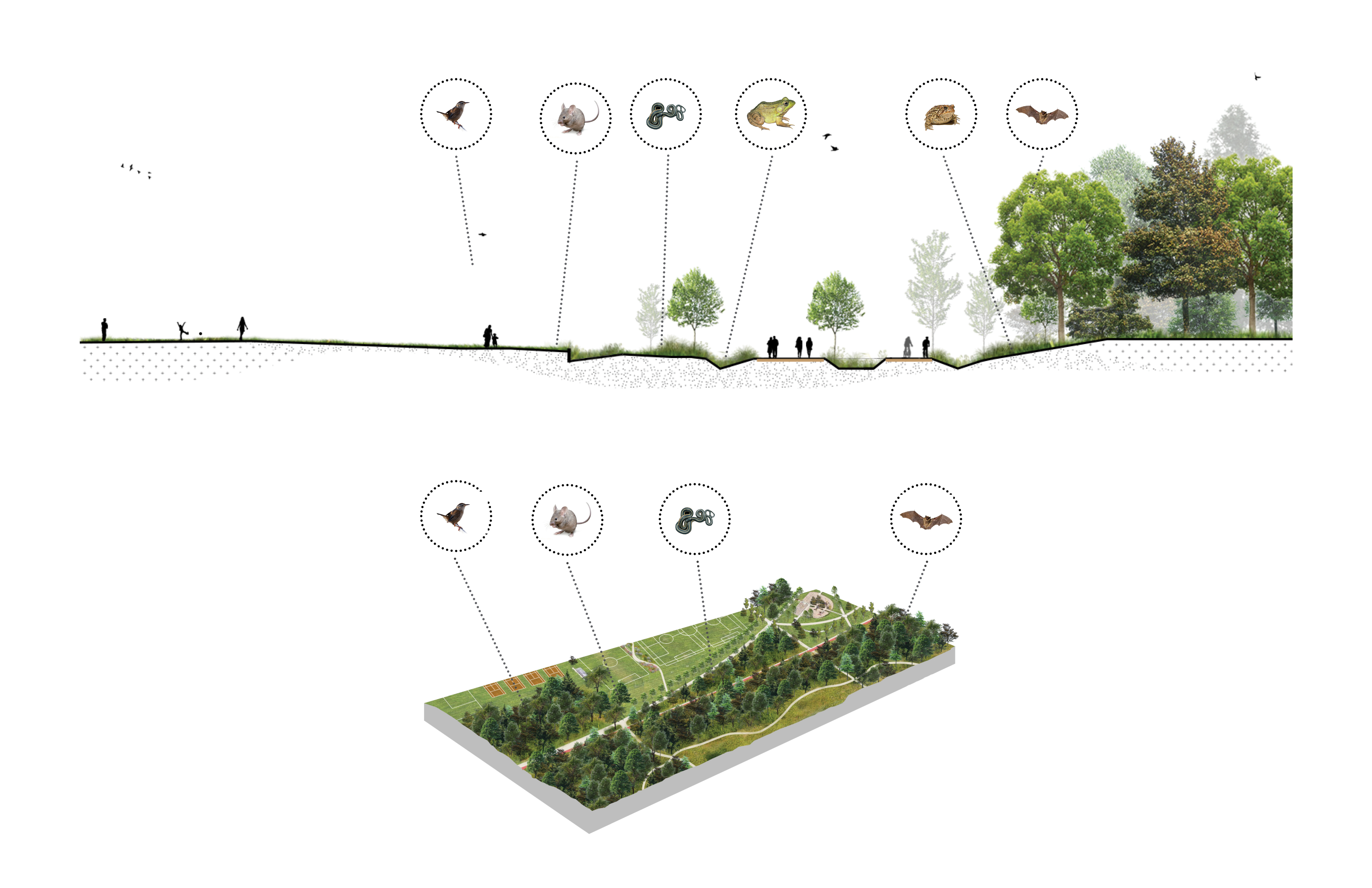
During planning and design, the project partners developed hybrid landscape concepts to address the extensive hardscaping and the monofunctional urban fabric, to identify and integrate four key landscape typologies:
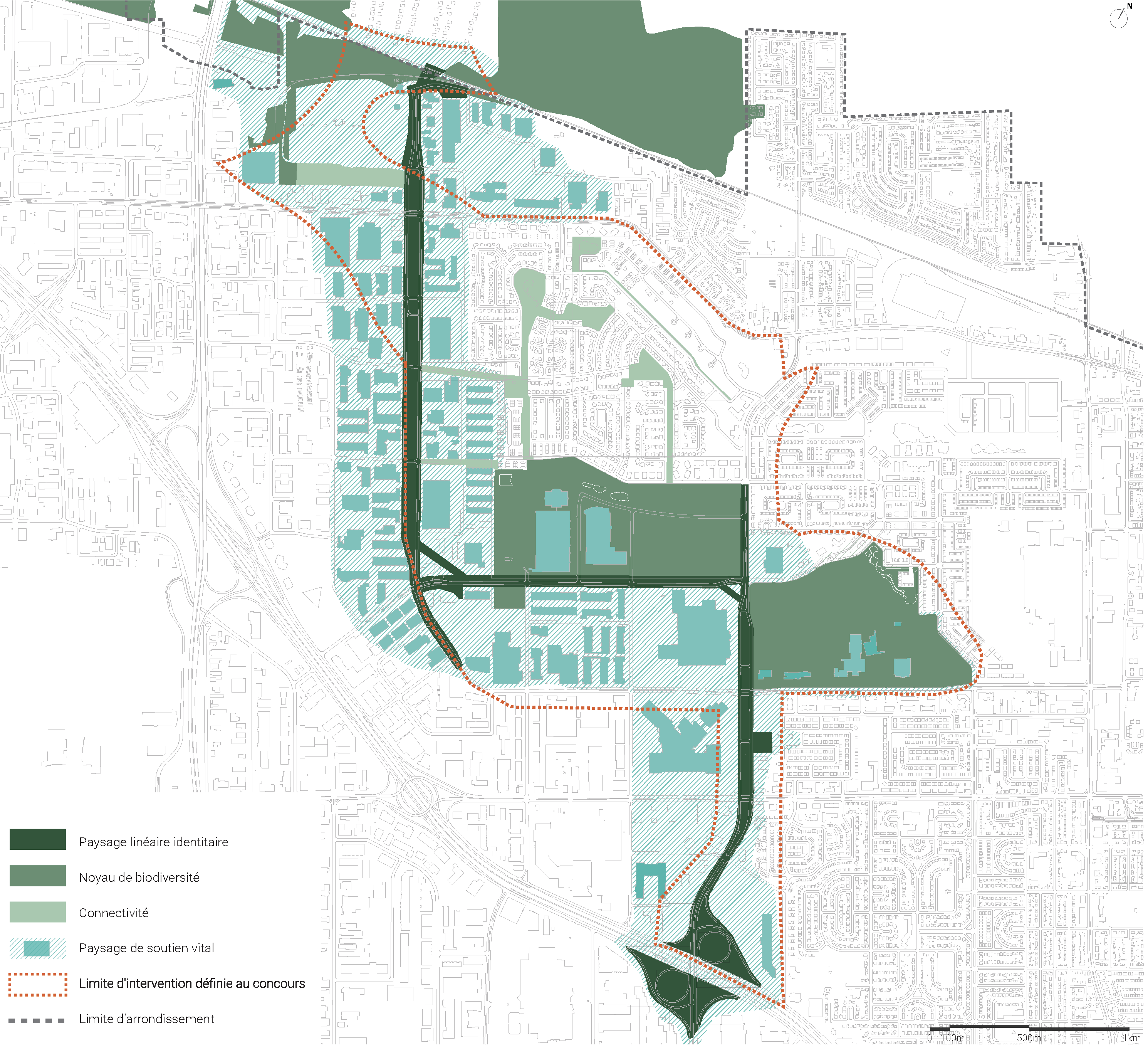
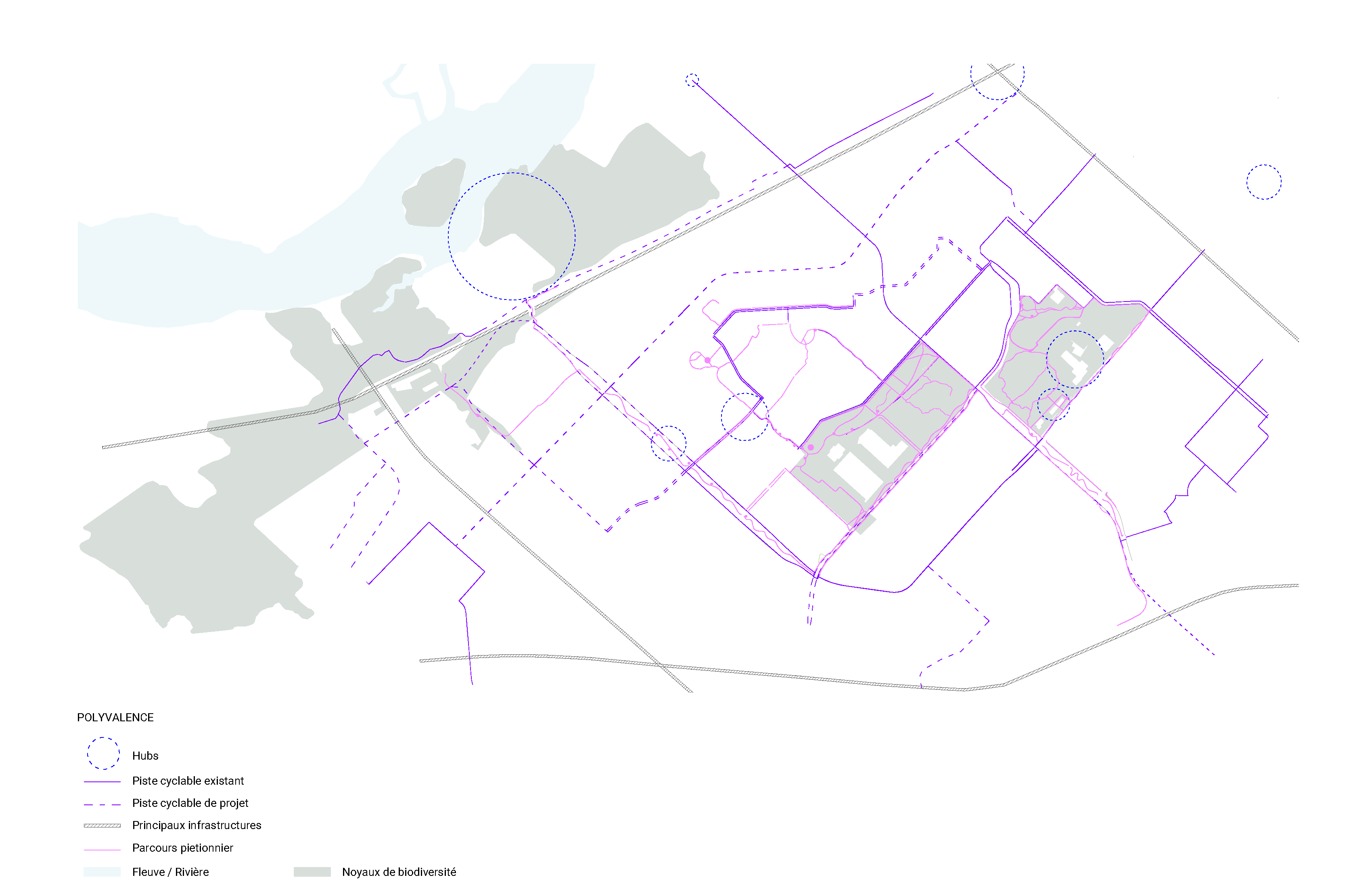
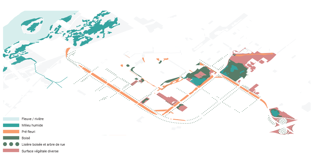
- Paysage linéaire identitaire (linear landscape identity): the primary connectivity backbone of the corridor
- Noyaux de biodiversité (biodiversity hotspots): areas of strong ecological potential
- Connectivité (connectivity): a secondary system of blue-green infrastructure and tree-lined spaces
- Paysages de soutien vital (landscapes of vital support): adjacent areas with ecological potential (outside municipal ownership) that can significantly reinforce the corridor through public voluntary actions such as green roofs, tree planting, and pollinator gardens on private land
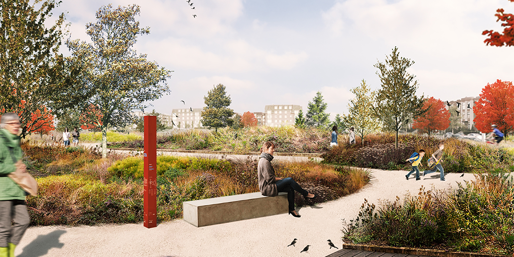
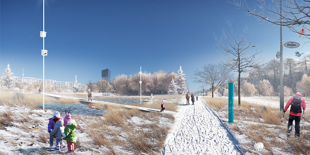
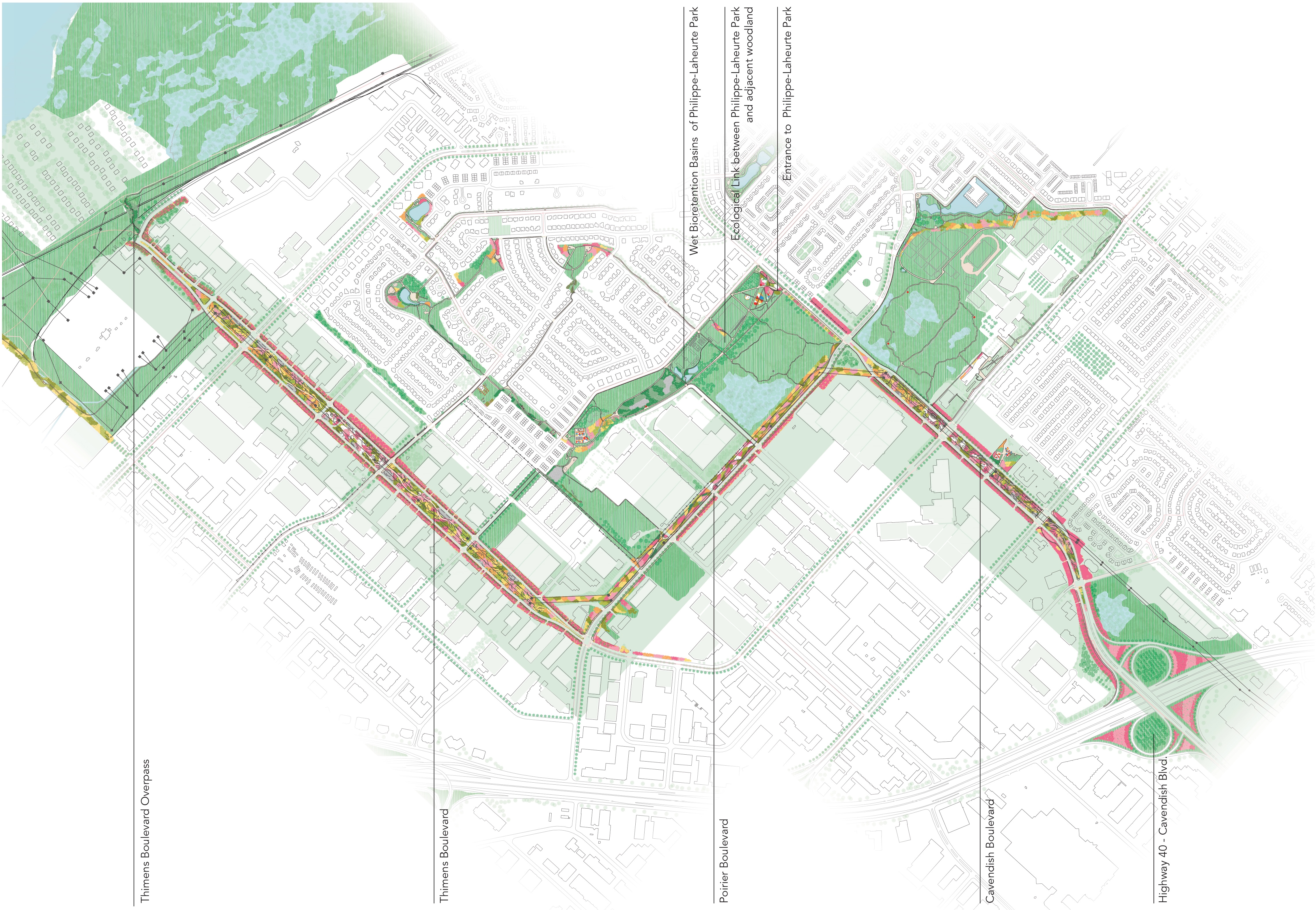
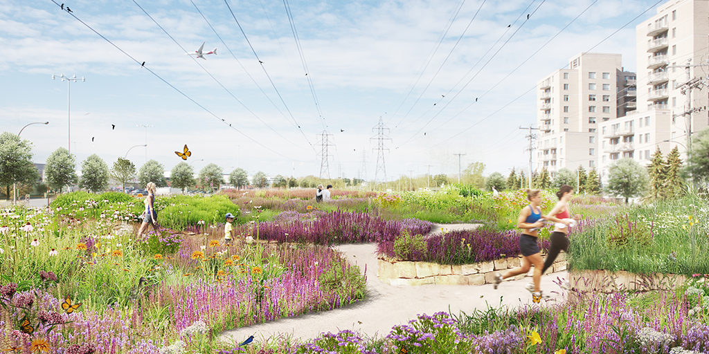
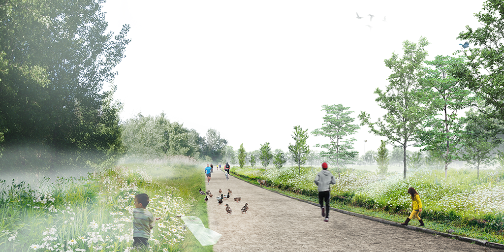
The overarching framework proposed for the corridor site presents continuous unifying landscape interventions along three main roads, extending to adjacent areas toward three identified “biodiversity hubs” that serve as critical anchor points and support complementary interventions. Central to development of the master plan was the identification of the corridor’s “backbone” – the underutilized land beneath major power lines alongside the major roads. The corridor master plan proposes the transformation of these linear underutilized spaces, to support flowering meadows that consist of wooded edges, ponds, pedestrian paths, and enhanced cycling infrastructure. These interventions will form a continuous corridor that connects existing and future green spaces by filling gaps in ecological and active-transportation connectivity. These interventions simultaneously increase vegetation cover, create new habitat opportunities for flora and fauna, and mitigate urban heat. In a similar way, proposed blue infrastructure in flood-prone areas builds on existing water management infrastructure, establishing a multi-layered approach to enhance biodiversity, strengthen ecological connectivity, and improve overall urban livability.
Summary of design intentions:
- Three-axis integration: Integrate water, soil and wildlife, and people as three key elements of blue-green-social infrastructure
- Connectivity across scales: Reconnect biodiversity hubs and increase access for people to a variety of nature-based environments
- Dynamic landscape and temporal planning: Recognize the landscape as evolving, with strategies for short-, medium-, and long-term adaptation
- Layered actions: Organize interventions by environmental and social objectives to promote coexistence supported by targeted actions and phased implementation
Implementation
The Saint‑Laurent Biodiversity Corridor master plan was officially adopted following a public presentation in May 2019. Implementation as outlined in the master plan is structured through short-term (0-5 years), medium-term (5-20 years), and long-term (20+ years) milestones that support four key priorities:
- The conservation and enhancement of existing natural environments;
- The creation of new habitats;
- The implementation of the ecological connectivity network; and
- The reinforcement of social and cultural spaces.
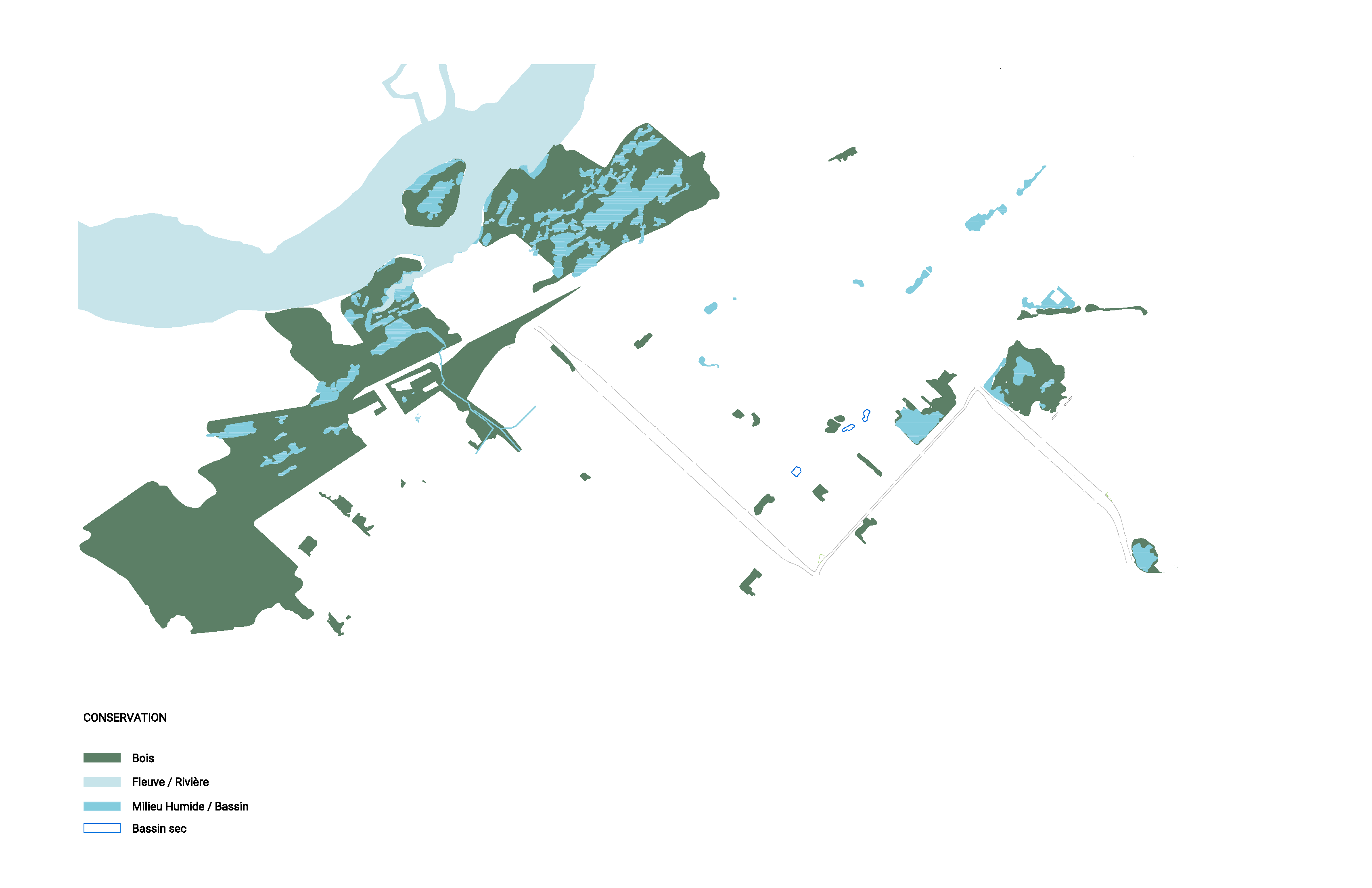
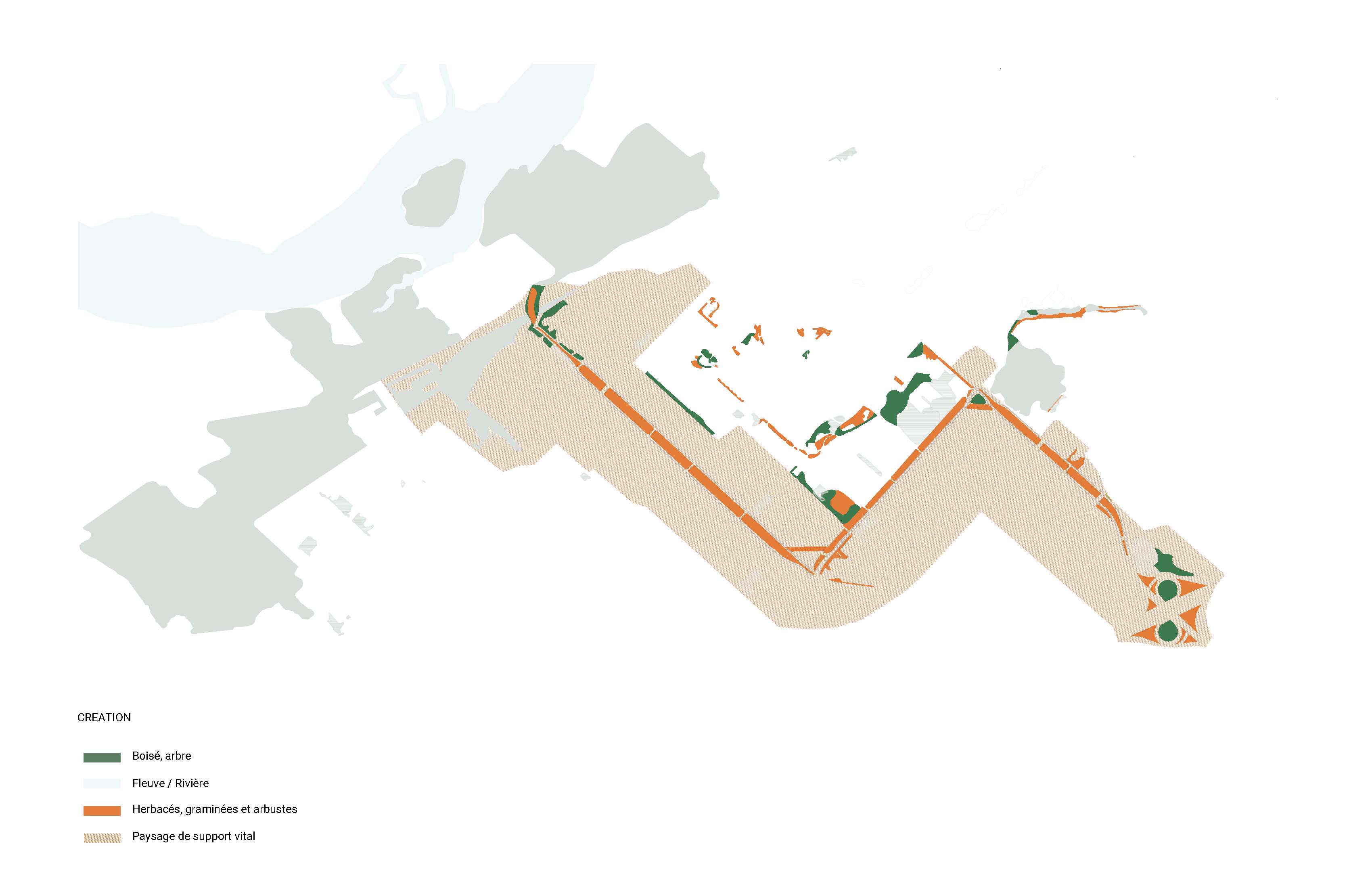
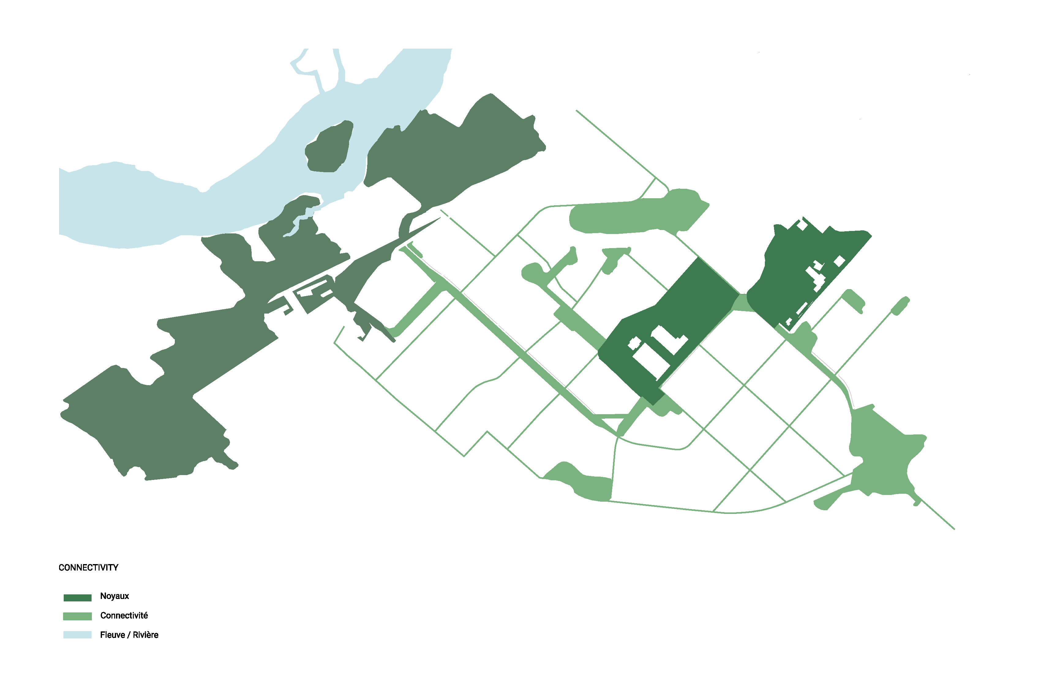
Mapping of general guidelines: conservation, creation, connectivity, and reinforcement. (Image: Project Team)
To operationalize these objectives, the master plan organizes implementation through layered interventions that are intended to be implemented concurrently, rather than a linear series of actions, to allow ecological and social processes to evolve together. Environmental layers include soil and water, as well as vegetation and wildlife, while human-centered layers address accessibility, and cultural and social activity. The proposed implementation process begins with soil regeneration to establish the foundational conditions for diverse habitats combined with a planting strategy, which aims to establish a layered ecological structure intended to initiate a gradual process of faunal repopulation to strengthen trophic relationships and enhance overall biodiversity. A network of public spaces are integrated into this framework, and are designed to improve microclimatic conditions, facilitate multimodal access, and improve green space accessibility, while also maintaining appropriate buffers from ecologically sensitive areas.
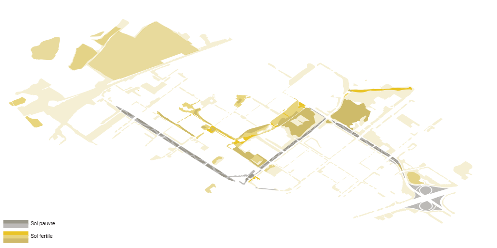
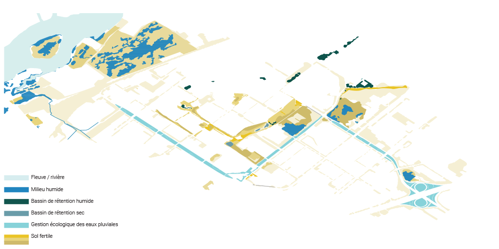
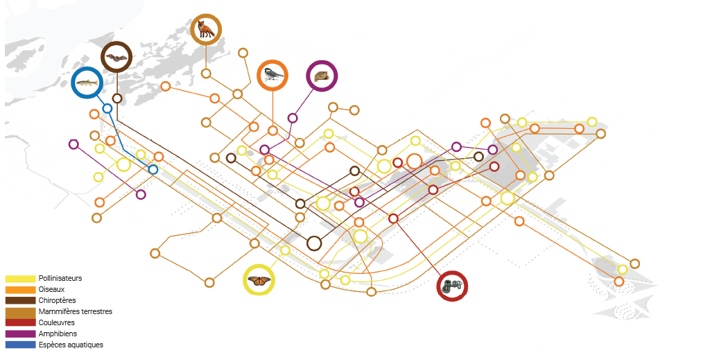
Mapping of environmental layers: soil, water, flora, fauna. (Image: Project Team)
While the master plan provides a general roadmap and a phasing strategy, implementation has required flexibility. A significant unexpected challenge during implementation was the discovery that Hydro-Quebec had pre-existing plans to upgrade the infrastructure along the corridor site. This presented a risk that newly implemented ecological interventions would be destroyed during future construction. As a result of the significant work needed to utilize the areas beneath the powerlines, implementation of the master plan has experienced a significant delay, underscoring the necessity of ongoing coordination with project partners in the future to ensure alignment between the master plan and utility operations.
Due to anticipated impacts from the hydro infrastructure upgrades, rather than proceeding with the phased implementation outlined in the master plan, the Borough has deferred major interventions and has instead concentrated on applying the master plan’s strategies in alternate locations. This adaptive sequencing has not only been affected by the infrastructure constraints but also by funding availability. While the Borough continues to allocate resources from its own budget, the overall approach to funding is incremental and tied to the delivery of specific project components. Participatory budgeting initiatives have provided financing for implementation thus far, and federal funding has been secured through climate adaptation programs contributing significantly toward related projects. Additional support is anticipated from Hydro-Québec in conjunction with the planned infrastructure upgrades, in addition to planned programs and related initiatives led by la Ville de Montréal (the City of Montreal) that will create opportunities to leverage funding in the future.
Work completed to date has been primarily completed by internal municipal staff, however, engagement by external consultants and contractors is anticipated as the project progresses. Phase 1 (concluded in 2021) established the corridor’s first functional section along the boulevards of Cavendish and Thimens, and included tree planting — including American red oak (Quercus rubra), Canadian serviceberry (Amelanchier canadensis), and red-osier dogwood (Cornus stolonifera) — garden bed planting adding seasonally adapted native species, in addition to avian habitat features such as nesting boxes and perches. Phase 2 (concluded in 2024) focused on the creation of green infrastructure and enhancing ecological connectivity between Parc Philippe-Laheurte, the Parc Marcel-Laurin forested area, and the Cavendish–Raymond-Lasnier forested area, vegetating underutilized open areas in the parks and along right-of-ways.
Outcomes and Monitoring
The Saint‑Laurent Biodiversity Corridor master plan represents an innovative approach of integrated blue, green, and social infrastructure. The project uniquely positions local-scale interventions within a larger regional ecological network to support biodiversity, enhance urban livability and connect people with nature, to build a climate-resilient city. The master plan was developed as a methodological framework that aims to reignite ecological processes, rather than delivering a single design. It proposes a nature-based identity for the public realm, with the intent that it can later be extended and applied elsewhere in Montreal as a flexible tool adaptable to different urban contexts.
A notable component of the project will be the integration of sites currently under private ownership. The strategy proposes adaptable interventions that extend beyond municipal boundaries to surrounding ecologically-supportive landscapes, referred to as paysage de soutien écologique, that will facilitate ecological and social continuity across public and private spaces. While these actions would be voluntary, they encourage collaboration between the public and private sector in support of shared environmental stewardship and social objectives. As one of the first initiatives to advance this type of integrated approach, the Saint‑Laurent Biodiversity Corridor master plan represents a precedent with applicability to other cities around the world.
The Saint‑Laurent Biodiversity Corridor master plan includes a suggested monitoring program to document ecological and social outcomes, and guide adaptive management. While implementation thus far has not directly aligned with the proposed framework, enhanced ecological connectivity and pollinator and avian activity along the corridor have been documented. The project has also attracted significant international attention: in 2019, the project was presented at the 5th edition of the Wuhan Design Biennale in China; in 2020, the project was awarded the National Urban Design Award from the Royal Architectural Institute of Canada, the Canadian Institute of Planners, and the CSLA; and in 2021, the project was the recipient of the CSLA’s Award of Excellence in the Planning and Analysis category.
Highlights of the Landscape Architect
The Saint-Laurent Biodiversity Corridor project places landscape architecture at the center of both the policy development process, and the planning and design process from the outset. The request for proposals initiated by la Ville de Montréal (the City of Montreal) was conceived as a landscape-led multidisciplinary design competition, signaling a shift toward landscape-first strategies that position ecological systems and social infrastructure as the foundation. The landscape architects and designers across the project partners led the project directly, developing the proposal from initial conceptual visioning to implementation strategies, while also working collaboratively with municipal staff, the multidisciplinary design team, and the Comité de suivi (steering committee).
The Saint-Laurent Biodiversity Corridor project demonstrates the role of the landscape architect not only in contributing to city-wide objectives and the master planning process, but also in mediating between disciplines, and between humans and ecology. Using the blue-green-social infrastructure framework, the knowledge and expertise of the landscape architect was critical in achieving an integration and balance of ecological and social objectives, ensuring that biodiversity, habitat, and environmental processes were prioritized alongside urban development, public realm, and community needs. In this way, the project further showcases the role of the profession in shaping urban identity. Rather than relying on traditional or purely aesthetic design elements, the landscape architects at LAND proposed that the borough’s identity emerge from this project, based on the increased presence of green infrastructure and urban nature, where ecological systems and everyday interactions with the landscape become the defining characteristic of place.
Next Steps
The next steps for implementation of the Saint‑Laurent Biodiversity Corridor master plan are evolving. From the municipal perspective, long-term implementation and maintenance will require greater ecological knowledge, specialized care, and targeted training for staff as the project progresses. Although current training efforts have been limited due to the small scale of early implementation, the Borough is identifying opportunities to advance internal expertise and integrate systematic monitoring and adaptive management. This approach will likely include tracking biodiversity outcomes and ecosystem functions by using both quantitative methods and participatory approaches, such as citizen science programs. Although internal monitoring is currently limited, the Borough aims to expand such efforts to respond to evolving stormwater and climate management needs and evaluate progress against implementation milestones. A final proposed intervention includes a wildlife overpass connection that will eventually extend the strategies for the Saint-Laurent corridor beyond the borough’s limits, to connect to larger ecological networks north across the Rivière-des-Prairies. Although this falls outside of the defined scope of the master plan, it was identified as a critical long-term opportunity to address the corridor’s current disconnect from broader regional green spaces, and underscores the need for ecological connectivity beyond administrative boundaries.
Ongoing coordination with project partners is needed to advance and resume the implementation of the master plan. While infrastructural constraints have resulted in implementation delays, they have provided new opportunities for project partners to consider additional avenues to integrate climate adaptation strategies and identify how future implementation can respond to evolving climate needs and align with international standards and frameworks, such as the EU definition of green infrastructure, the Kunming-Montreal Global Biodiversity Framework, and Natural Capital Accounting and Valuation of Ecosystem Services (SEEA EA). While the Saint‑Laurent Biodiversity Corridor master plan provides a strong foundation for supporting both biodiversity and climate resilience, aligning future actions with international frameworks enables new opportunities to measure ecosystem services, evaluate natural capital, and ensure that interventions deliver co-benefits for both the environment and the Saint-Laurent community.
The long‑term wildlife overpass bridge would connect Saint‑Laurent’s biodiversity corridor to nearby nature parks and boroughs across the railway. (Image: Project Team)
Resources
- Ville de Montreal (2025) - Saint-Laurent Biodiversity Corridor, project page
- Corridor de biodiversité de Saint-Laurent - Plan directeur d'aménagement (2019)
- CSLA/AAPC Awards page [ENG] [FN]
- LAND Italia - Biodiversity Corridor, Montréal, project portfolio
- Civiliti - Saint-Laurent Biodiversity Corridor, project portfolio
- Biodiversité conseil - Plan directeur: Corridor de biodiversité Saint-Laurent
![]()
This case study was prepared and authored by Sabrina Careri (Design Communications) on behalf of the CSLA.
It forms part of the landADAPT Case Study Series, an educational resource and advocacy tool developed by the CSLA with the support of Natural Resources Canada’s Climate Change Adaptation Program.